There is nothing more relaxing and refreshing than walking aimlessly around the city letting go all the negative and toxic energy inside you. Nevertheless, Cahir is the best place especially for walking enthusiasts, the pleasurable sights of Galty, Knockmealdowns, Comeraghs and the majestic Slievenamon Mountains are delightful for walking.
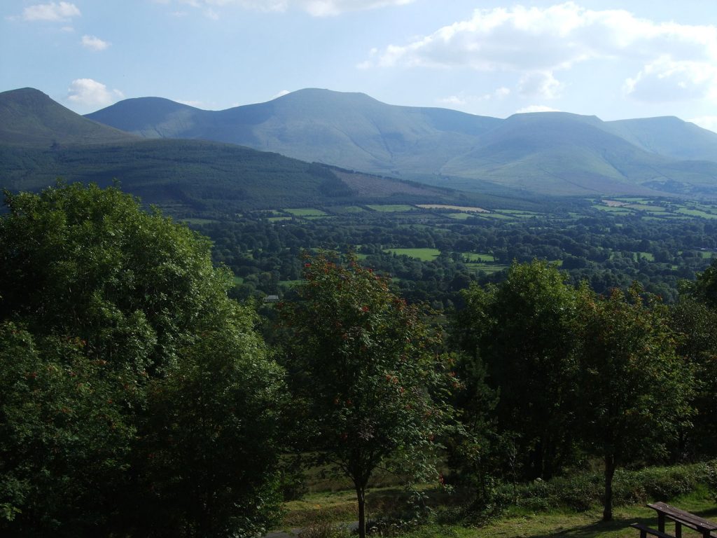
The Galty Mountains
The Galty (Galtee) Mountain range is about 10 minute away from Cahir. About 919m Galtymore has the highest inland peak in Ireland and it is famous and most recommended among hikers in Ireland. It has unique double summit and has a steep surface on the north side. This summit is excellent climb for a good day of hiking, especially the smaller Galtybeg peak.
The Knockmealdown Mountains
The Knockmealdown or ‘The Vee’ Mountains is best known for its V-shaped gap between the peaks. It is located at the border of Tipperary and Waterford border. It is almost 20 minutes away from Cahir, the pace is surrounded with great relaxing views as well as beautiful mountain lake Bay Lough. The place has plenty of parking space so you can just sit there and admire the beauty. The place is great for walking too with several roads and walking routes. Knockmealdown Mountain is also one if the highest mountain in Ireland with the highest point of about 794 meters.
The Comeragh Mountains…
The Comeragh Mountains, the name came from the word Coumarach that means ‘full of hollows, glacial in origin’ is one of the finest corrie lake in entire Europe, the lake is situated with in the drive of 25 minutes from Cahir. The word ‘cvm’, which is pronounced ‘coum’, is the international term for hanging valleys.
Slievenamon
The majestic Slievenamon Mountain also known as ‘maiden’s mountain’ is famous for its mention in songs, prose and poem, and Ireland of history. The mountain has the highest peak of about 721 meters with a spellbinding 360’ degree view on a clear fine day.
Way-marked Trails
Flourishing long-distance trails in the mountain for walking (visit www.walkireland.ie for details). These trails include the East Munster Way that is the coast-to-coast path of Dublin to Kerry and St Declan’s way that is just along the path of St Patrick from Cashel to Ardmore. The Tipperary Heritage Trail that has been formed few years ago trails from The Vee to Cashel. This route brings the hikers to some great sights along the way and also includes so much information about all these sites.
An 80km (50mile) walk to the Ballyhoura Way is distant trail that is divided into 7 divisions and each represents half days walking. The closest division to Cahir is Lisvernane to Tipperary town.
A luxury valley between the Galty Mountains and wooded range of Slievenamuck, where the Aherlow River also streams. The area is bounded by the rural villages Galbally and Bansha, which was historically the Limerick and Tipperary. Two walking trails have been developed there, one near the statue of Christ the King and one at Lisvernane.
Suggested Walks
Swiss Cottage Walk (Coronation Walk)
Easy riverside walkof about 4kms
Starting from Cahir Castle Car Park, follow the direction of southwards to the Swiss Cottage and return is by the same track. The place was once part of the Butler-Charteris Land; the family named it after the coronation of George IV in 1821, where they socialised. This stroll runs besides the River Suir and is surrounded by natural broadleaf woodland. Planted since the 1790’s, mature beech, oak, Spanish chestnut, sycamore, laurel, rhododendrons and other plants can be seen. The area is swarmed with nature. Swans, duck are common, as well as red squirrel, pheasant and woodcock.
Millenium Trail—Glengarra Wood
7km (4.4miles) Grade: Medium.
Glengarra Wood is located at 13km on the west of Cahir town by the R639. The woods growsuphill on the southern hills of the Galty mountains. Some parts of the woodland have been developed for visitors. The facilities for tourist and visitors include car parking space, log bridges, picnic tables, and facts and figured boards that gives the information about the names of the different tree types,and etc. The place is filled with so many fine sample trees, which include the giant Californian Redwood, which was planted during the period when the area was the part of the Viscount Lismore (Shanbally Castle) possession. In the early summer days, the rhododendron flowers make a beautifulpageant. The track and trails can be murky in places. At some point it would become necessary to cross the stream. Hikers can also choose to do this or go back over to their carpark.
Galtymore from the South
Rated: Moderate difficult, could be done in 4-5 hours in fast pace.
The idea of reaching the mountain from the southern side on the Black Road offers a panoramic landscape view of the mountain. The slow nature of the hike makes the mounting relatively easy and straightforward to 919m (3015 feet). The OS Discovery Series Map 74 has covered most of this area, take the R639 from Cahir in the route of Cork. Trailthe signs for Kilcoran Lodge or Skeheenarinky. At GR(9070 1760) take a turn to right, which has a road sign for Galtymore then drive straight along this road for about 3.5km until the GR(8930 2035) the small car park.
.
For detailed directions, please visit,
For further information Ordnance Survey maps 74 (for the Galty and Knockmealdown mountains) and 75 (for the Comeraghs) are the best option for first timers and also for driving on the back roads. You can also order these from www.osi.ie/en/starticle/discovery-series.aspx
National Waymarked Ways offer hikers about 3,000 km of marked walking routes for entire Ireland. There is also an intriguing interactive map at www.walkireland.ie
Local walking clubs…
www.peaksmcclonmel.ie and www.galteewalkingclub.ie both have amazing service for guest walkers. Their meet ups are generally on Sundays.
www.coillteoutdoors.ie Ireland’s forestry company Coillte, arrange great hiking trails near Cahir. You can visit their packages on their website.
Safety on Mountains
Hiking can be dangerous and risky anywhere and it goes with mountains in Ireland too. The weather condition can be change with a blink of an eye and can completely change the mood and setting of the place resulting in the vacation stroll can be easily turned into quest of survival. Therefore, it is better to go with safety precautions and be well prepared for anything that can surprise you during hiking. Prepare yourself with some good mount climbing boots, extra blanket, food and drinks. Most importantly, good navigational skills can come in handy, so take a map and a campus with you and learn how to use them correctly. Some of the hiking tracks may have some direction marks but do not rely on it. Carry a direction marker or cairns so you can mark the route.
An electronic GPS unit is also useful; however, do not forget to carry a campus too. Also, set your GPS to Irish Datum and Grid system. You can also learn about grid system on (Ordnance Survey Ireland) Discovery Series Maps if you are not aware of it, it is very easy to learn.
Also, always tell someone about your route and expected time return. The signals might not be stable there so do not rely on mobile phones for communication.
If you have some doubt or you are unsure about anything, you should contact the walking clubs mentioned above.